Home » All prints and maps

 
China, Boat Girl, 1814/1820

China, Boat Girl, 1814/1820.
" A Boat Girl " aquatint with original hand colour published by John Murray in William Alexander's The Dress & Manners of the Chinese, London, 1814. Printed on Whatman's "Turkey Mill" paper. Supplied with separate page of text description. Size of image about 12 x 16 cms. Ref D6144

 
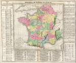
France, with Battles marked, Lavoisne 3rd edn, 1821

France, with Battles marked, Lavoisne 3rd edn, 1821.
" Geographical and Statistical Map of France ", "divided into Governments indicating the places rendered celebrated by Battles or Sieges " by C.Gross, engraved by J.Yeager, published by M.Carey & Son in A Complete Genealogical, Historical, Chronological and Geographical Atlas .. by M.Lavoisne, third American (Philadelphia) edition, 1821. Various notes and statistics around and below the map. Key to the marked battle and siege sites below the map itself. Detail showing part of the map. Copper engraving with full original hand colour, centre-fold as published. Some browning down centre-fold and slight soiling. Margins of 1 cms or more. Overall size 51 x 41.5 cms. Ref D6116

 
Scotland, Cassencarie Bay, anonymous painting, 1889

Scotland, Cassencarie Bay, anonymous painting, 1889.
"Cassancary Bay" (modern Cassencarie) anon, dated 1889. Watercolour on textured paper, old dark scrapbook paper adheres to the reverse. Size 31.5 x 23 cms. Ref D6106


Canada, British Columbia, Cariboo area, RGS Journal, 1864

Canada, British Columbia, Cariboo area, RGS Journal, 1864.
" Reconnaisance Sketch of part of Cariboo by Lieut. H.S.Palmer R.E. " engraved by Edward Weller and published in the Journal of the Royal Geographical Society, 1864. Steel engraved map, on very thin paper. Two folds as published. Good condition. Size 24.5 x 19 cms. Ref D6090

 
Central America, SDUK, 1844

Central America, SDUK, 1844.
" Central America ... " engraved by J. & C. Walker, published by The Society for the Diffusion of Useful Knowledge (SDUK), about 1842. Steel engraved map with original outline hand colour. Detail showing the Mexico City area. Slight age browning. Size 39.5 x 31 cms. Ref D6081

 
Egypt, Sinai, El Hesweh near Rephidim, 1875

Egypt, Sinai, El Hesweh near Rephidim, 1875.
"El Hesweh, Rephidim" (near Red Sea) engraved by E.Brandard after a picture by Harry Fenn, published in Picturesque Palestine, about 1875. Steel engraved print with recent hand colour. Size 18 x 25 cms. Ref D6079


Israel, Plains of Jericho, 1880

Israel, Plains of Jericho, 1880.
"The Plains of Jericho" engraved by C.Cousen after a picture by Harry Fenn, published in a bible about 1880. Steel engraved print with recent hand colour. Size 25 x 17 cms. Ref D6078

 
Butterflies, 1882

Butterflies, 1882.
Butterfly print published in European Butterflies and Moths, 1882. Chromolithograph, size about 17 x 22 cms (6.5 x 8.5 inches) plus margins. NOTE - there is no explanation to the print. Ref D6072

 
Butterflies, 1882

Butterflies, 1882.
Butterfly print published in European Butterflies and Moths, 1882. Chromolithograph, size about 17 x 22 cms (6.5 x 8.5 inches) plus margins. NOTE - there is no explanation to the print. Ref D6071


Butterflies, 1882

Butterflies, 1882.
Butterfly print published in European Butterflies and Moths, 1882. Chromolithograph, size about 17 x 22 cms (6.5 x 8.5 inches) plus margins. NOTE - there is no explanation to the print. Ref D6068

 
Old World Mountain Chains, Johnston Physical Atlas, 1850

Old World Mountain Chains, Johnston Physical Atlas, 1850.
" The Mountain Chains of Europe and Asia " engraved by W. & A.K. Johnston, published by William Blackwood & Sons in Johnston's Physical Atlas, 1850. Steel engraved map with original hand colour. Detail showing part of the map. Good condition with wide margins. Size 26 x 20.5 cms. Ref D6056

 
The World, hydrographic, 1866

The World, hydrographic, 1866.
" Carte Hydrographique des Parties Connues de la Terre ... " engraved by Pepin-Malherbe and published in Chasseloup-Laubat's Atlas des Colonies Francaises, Paris, 1866. Steel engraved map, with original hand colour in blue to the French colonies. Centrefold as published, good condition with wide margins. Size 42 x 27.5 cms. Ref D6055


Sweden & Norway map, 1858

Sweden & Norway map, 1858.
" Sweden and Norway with Russian Finland by G.H.Swanston Edinr. " engraved by G.H.Swanston and published by A.Fullarton & Co. in The Companion Atlas to The Gazetteer of the World, about 1858. Steel engraved map with original hand colour in delicate pastel shades. On thick paper, with plate mark and good margins. Small inset map showing the environs of Stockholm. Detail showing part of the map. Centre-fold as published, good condition. Size 40 x 50 cms. Ref D6034

 
Europe, Railways, Swanston/Fullarton, c1858

Europe, Railways, Swanston/Fullarton, c1858.
" Central Europe with the Railways ... by J. Bartholomew Jun. " published by A.Fullarton & Co. in The Companion Atlas to The Gazetteer of the World, about 1858. Lithographic map with original hand colour. On thick paper, with good margins. Showing all railways completed or in progress, colour coded to according to country. Detail showing part of the main map. Centre-fold as published, good condition. Size 51 x 41 cms. Ref D6031

 
Crimea, Fort Nicholas Interior, Simpson, 1855

Crimea, Fort Nicholas Interior, Simpson, 1855.
"Interior of Fort Nicholas" lithographed by E.Walker after a drawing by W.Simpson, published by Paul & Dominic Colnaghi in The Seat of War in the East, 1855. Fine large tinted lithograph on heavy paper, with wide margins. Small pinprick registration holes barely visible in each lower corner. Some foxing, mostly in margins. Size 42 x 24 cms. Ref D6027


South America, 1853

South America, 1853.
"South America" engraved by Sidney Hall and published in Butler's Atlas of Modern Geography, 1853. Steel engraved antique map with original hand colour. Centrefold as published, slight soiling. Size 19 x 25.5 cms. Ref D6015

 
United States, Atlas of Modern Geography, 1853

United States, Atlas of Modern Geography, 1853.
"United States" engraved by Sidney Hall and published in Butler's Atlas of Modern Geography, 1853. Steel engraved antique map with original hand colour. Detail showing part of the Eastern states and further detail showing the central states. Centrefold as published. Size 26 x 20 cms. Ref D6013

 
France, Atlas Modern Geography, 1853

France, Atlas Modern Geography, 1853.
" France " engraved by Sidney Hall and published in Butler's Atlas of Modern Geography, 1853. Steel engraved map with original hand colour. Centrefold as published, some soiling. Size 26 x 20 cms. Ref D5998

 
« Previous | 2100 | 2101 | 2102 | 2103 | 2104 | 2105 | 2106 | 2107 | 2108 | 2109 | 2110... | Next »


© 2003 - 2020 Website copyright Steve Bartrick
Royalty free stock images of antique prints of interest to historians, students and family history researchers