Home » Antique maps » Europe maps >>> » Ireland antique maps

 
Ireland, route map with Maryborough, Ballynakill & Kilkenny, 1783

Ireland, route map with Maryborough, Ballynakill & Kilkenny, 1783.
[ Part of the Dublin to Tipperary route ] engraved by G.Terry and published in Taylor and Skinner's Maps of the Roads of Ireland, (2nd edition), 1783. Includes Maryborough, Ballynakill & Kilkenny. On the verso is part of the Dublin to Dingle route, including Dingle. Copper engraved map. Size 12 x 21.5 cms plus good margins. Ref F5747

 
Ireland, route map with Tralee, Castle Island & Abbey Feale, 1783

Ireland, route map with Tralee, Castle Island & Abbey Feale, 1783.
[ Part of the Dublin to Tralee route ] engraved by G.Terry and published in Taylor and Skinner's Maps of the Roads of Ireland, (2nd edition), 1783. Includes Tralee, Castle Island & Abbey Feale. On the verso is part of the Dublin to Dingle route, including Dingle. Copper engraved map. Size 12 x 21.5 cms plus good margins. Ref F5746

 
Ireland, route map with Tralee, Ardfert, Listowell & Glynn, 1783

Ireland, route map with Tralee, Ardfert, Listowell & Glynn, 1783.
[ Part of the Dublin to Tralee route ] engraved by G.Terry and published in Taylor and Skinner's Maps of the Roads of Ireland, (2nd edition), 1783. Includes Tralee, Ardfert, Listowell, Shanagolden & Glynn. On the verso is the previous part of this route, including Listowell, Abbydorny and Abbey Feale. Copper engraved map. Size 12 x 21.5 cms plus good margins. Ref F5745


Ireland, route map with Askeyton, Rathkeale, Newcastle & Shanagolden, 1783

Ireland, route map with Askeyton, Rathkeale, Newcastle & Shanagolden, 1783.
[ Part of the Dublin to Tralee route ] engraved by G.Terry and published in Taylor and Skinner's Maps of the Roads of Ireland, (2nd edition), 1783. Includes Askeyton, Rathkeale, Newcastle & Shanagolden. On the verso is the start of this route, including Limerick and Adair. Copper engraved map. Size 12 x 21.5 cms plus good margins. Ref F5744

 
Ireland, route map with Limerick, Newport & Shannon River, 1783

Ireland, route map with Limerick, Newport & Shannon River, 1783.
[ Part of the Dublin to Limerick route ] engraved by G.Terry and published in Taylor and Skinner's Maps of the Roads of Ireland, (2nd edition), 1783. Includes Limerick, Newport & Shannon River. On the verso is part of the Dublin to Ennis route, including Nenagh, and Killaloe. Copper engraved map. Size 12 x 21.5 cms plus good margins. Ref F5743

 
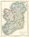
Ireland map, 1827

Ireland map, 1827.
"Ireland" drawn and engraved by Sidney Hall, published in A general Atlas of Ancient & Modern Geography, 1827. Steel engraved antique map with original hand colouring. Size 18.5 x 24.5 cms plus margins. Ref F5218


Ireland, route map with Toomavara, Nenagh and O'Briens Bridge Road, 1783

Ireland, route map with Toomavara, Nenagh and O'Briens Bridge Road, 1783.
[ Part of the Dublin to Limerick route ] engraved by G.Terry and published in Taylor and Skinner's Maps of the Roads of Ireland, (2nd edition), 1783. Includes Toomavara, Nenagh and O'Briens Bridge Road. On the verso is part of the same route, including Maryboro, Montrath, Burros in Ossory and Roserea. Copper engraved map. Size 12 x 21.5 cms plus good margins. Ref F5119

 
Ireland, route map with Dublin, Racool, Johnstown and Naas, 1783

Ireland, route map with Dublin, Racool, Johnstown and Naas, 1783.
[ Part of the Dublin to Limerick route ] engraved by G.Terry and published in Taylor and Skinner's Maps of the Roads of Ireland, (2nd edition), 1783. Includes Dublin, Racool, Johnstown and Naas. On the verso is part of the same route, including Naas, Kildare, Monasterevan and Ratheen Common. Copper engraved map. Size 12 x 21.5 cms plus good margins. Ref F5118

 
Ireland, route map with Dublin, Lucan, Cellbridge and Killybegs, 1783

Ireland, route map with Dublin, Lucan, Cellbridge and Killybegs, 1783.
[ Part of the Dublin to Kildare & Portarlington route ] engraved by G.Terry and published in Taylor and Skinner's Maps of the Roads of Ireland, (2nd edition), 1783. Includes Dublin, Lucan, Cellbridge and Killybegs. On the verso is part of the same route, including Grand Canal, Kildare and Portarlington. Copper engraved map. Size 12 x 21.5 cms plus good margins. Ref F5117


Ireland, route map with Dublin, Leixlip, Maynooth and Trim, 1783

Ireland, route map with Dublin, Leixlip, Maynooth and Trim, 1783.
[ The Dublin to Trim route via Killcock ] engraved by G.Terry and published in Taylor and Skinner's Maps of the Roads of Ireland, (2nd edition), 1783. Includes Dublin, Leixlip, Maynooth and Trim. On the verso is part of the Dublin to Ennis route, including Loughrea, Gort, Crusheen and Ennis. Copper engraved map. Size 12 x 21.5 cms plus good margins. Ref F5116

 
Ireland, route map with Loughrea and Athenry, 1783

Ireland, route map with Loughrea and Athenry, 1783.
[ Part of the Dublin to Birr route ] engraved by G.Terry and published in Taylor and Skinner's Maps of the Roads of Ireland, (2nd edition), 1783. Includes Loughrea and Athenry. On the verso is part of the Dublin to Galway route, including Oranmore, Galway and Barracks on Lough Corrib. Copper engraved map. Size 12 x 21.5 cms plus good margins. Ref F5115

 
Ireland, route map with Birr, Banagher & Eyre Court, 1783

Ireland, route map with Birr, Banagher & Eyre Court, 1783.
[ Part of the Dublin to Galway & Birr route ] engraved by G.Terry and published in Taylor and Skinner's Maps of the Roads of Ireland, (2nd edition), 1783. Includes Birr, Banagher & Eyre Court. On the verso is part of the same route, including Heronsbrooke and Ballydugan. Copper engraved map. Size 12 x 21.5 cms plus good margins. Ref F5103


Ireland, route map with Balliboy, Frankford & Cloghan, 1783

Ireland, route map with Balliboy, Frankford & Cloghan, 1783.
[ Part of the Dublin to Galway & Birr route ] engraved by G.Terry and published in Taylor and Skinner's Maps of the Roads of Ireland, (2nd edition), 1783. Includes Balliboy, Frankford & Cloghan. On the verso is part of the same route, including Philipstown, Ballinagar, Killeigh and Tullamore. Copper engraved map. Size 12 x 21.5 cms plus good margins. Ref F5103

 
Ireland, route map with Dublin, Leixlip and Maynooth, 1783

Ireland, route map with Dublin, Leixlip and Maynooth, 1783.
[ Part of the Dublin to Galway route ] engraved by G.Terry and published in Taylor and Skinner's Maps of the Roads of Ireland, (2nd edition), 1783. Includes Dublin, Pulmers Town, Leixlip and Maynooth. On the verso is part of the same route, including Kilcock, Cloncurry, Johnston Bridge, Castlecarbery and Edenderry. Copper engraved map. Size 12 x 21.5 cms plus good margins. Ref F5102

 
Ireland, route map with Kilbeggan, Clara, and Fearbane, 1783

Ireland, route map with Kilbeggan, Clara, and Fearbane, 1783.
[ Part of the Dublin to Loughrea route ] engraved by G.Terry and published in Taylor and Skinner's Maps of the Roads of Ireland, (2nd edition), 1783. Includes Kilbeggan, Clara, Ballycumber and Fearbane. On the verso is part of the same route, including Ballinasloe, Aghrim and Loughrea. Copper engraved map. Size 12 x 21.5 cms plus good margins. Ref F5101


Ireland, route map with Newtown Bellew, Tuam & Hollymount, 1783

Ireland, route map with Newtown Bellew, Tuam & Hollymount, 1783.
[ Part of the Dublin to Castlebar route ] engraved by G.Terry and published in Taylor and Skinner's Maps of the Roads of Ireland, (2nd edition), 1783. Includes Newtown Bellew, Tuam & Hollymount. On the verso is part of the same route, including Athlone, Balliforan and Mt. Bellew. Copper engraved map. Size 12 x 21.5 cms plus good margins. Ref F5100

 
Ireland, route map with Castlebar, Balcarra & Newport, 1783

Ireland, route map with Castlebar, Balcarra & Newport, 1783.
[ Part of the Dublin to Castlebar and Newport route ] engraved by G.Terry and published in Taylor and Skinner's Maps of the Roads of Ireland, (2nd edition), 1783. Includes Castlebar, Balcarra and Newport. On the verso is part of a route from Dublin to Dunmore, including Ballinamore, Ahascragh, Newtown Bellew and Dunmore. Copper engraved map. Size 12 x 21.5 cms plus good margins. Ref F5099

 
Ireland, route map with Colerain, Portrush and Dungiven, 1783

Ireland, route map with Colerain, Portrush and Dungiven, 1783.
[ Dungiven to Colerain route ] engraved by G.Terry and published in Taylor and Skinner's Maps of the Roads of Ireland, (2nd edition), 1783. On the verso is part of a route to Colerain, including Garvagh, Swatteragh and Kilrea. Copper engraved map. Size 12 x 21.5 cms plus good margins. Ref F4896

 
« Previous | 1 | 2 | 3 | 4 | 5 | 6 | 7 | 8 | 9 | 10... | Next »


© 2003 - 2020 Website copyright Steve Bartrick
Royalty free stock images of antique prints of interest to historians, students and family history researchers