Home » All prints and maps

 
Ireland, route map with Carlow, Tullow, Newtown Barry & Enniscorthy, 1783

Ireland, route map with Carlow, Tullow, Newtown Barry & Enniscorthy, 1783.
[ The Carlow to Tullow and Enniscorthy to Newtown Barry routes ] engraved by G.Terry and published in Taylor and Skinner's Maps of the Roads of Ireland, (2nd edition), 1783. Includes Carlow, Tullow, Newtown Barry & Enniscorthy. On the verso is the Enniscorthy to Burris route. Copper engraved map. Size 12 x 21.5 cms plus good margins. Ref F5785

 
Ireland, route map with New-Ross, Fetland, Clomines & Tintern, 1783

Ireland, route map with New-Ross, Fetland, Clomines & Tintern, 1783.
[ The New-Ross to Fethard & Wexford to Tintern routes ] engraved by G.Terry and published in Taylor and Skinner's Maps of the Roads of Ireland, (2nd edition), 1783. Includes New-Ross, Fetland, Clomines & Tintern. On the verso is the Enniscorthy to New-Ross route. Copper engraved map. Size 12 x 21.5 cms plus good margins. Ref F5784

 
Ireland, route map with Wexford & New-Ross, 1783

Ireland, route map with Wexford & New-Ross, 1783.
[ The Wexford to New-Ross & Waterford route ] engraved by G.Terry and published in Taylor and Skinner's Maps of the Roads of Ireland, (2nd edition), 1783. Includes Wexford, Taghmon & New-Ross. On the verso is the Wexford to Waterford route. Copper engraved map. Size 12 x 21.5 cms plus good margins. Ref F5783


Ireland, route map with Dublin & Howth, 1783

Ireland, route map with Dublin & Howth, 1783.
[ The Dublin to Howth route ] engraved by G.Terry and published in Taylor and Skinner's Maps of the Roads of Ireland, (2nd edition), 1783. Includes Dublin & Howth. On the verso is part of the Dublin to Powerscourt & Rathdrum route, including Dublin, Enniskerry & Rathdrum. Copper engraved map. Size 12 x 21.5 cms plus good margins. Ref F5782

 
Ireland, route map with Rathdrum, Aghrim, Shilelagh & Clonegall, 1783

Ireland, route map with Rathdrum, Aghrim, Shilelagh & Clonegall, 1783.
[ Part of the Dublin to Clonegall & Carnew route ] engraved by G.Terry and published in Taylor and Skinner's Maps of the Roads of Ireland, (2nd edition), 1783. Includes Rathdrum, Aghrim, Shilelagh & Clonegall. On the verso is part of the Dublin to Hacketstown and Carnew to Gorey routes, including Ballybeg, Hacketstown, Carnew & Gorey. Copper engraved map. Size 12 x 21.5 cms plus good margins. Ref F5781

 
Ireland, route map with Enniscorthy, Wexford & Taghmon, 1783

Ireland, route map with Enniscorthy, Wexford & Taghmon, 1783.
[ Part of the Dublin to Wexford & Taghmon route ] engraved by G.Terry and published in Taylor and Skinner's Maps of the Roads of Ireland, (2nd edition), 1783. Includes Enniscorthy, Wexford & Taghmon. On the verso is part of the Dublin to Wexford route, including Neville Court & Wexford. Copper engraved map. Size 12 x 21.5 cms plus good margins. Ref F5780


Ireland, route map with Wicklow, Arklow and Rathdrum, 1783

Ireland, route map with Wicklow, Arklow and Rathdrum, 1783.
[ Part of the Dublin to Clonegall & Carnew via Rathdrum route ] engraved by G.Terry and published in Taylor and Skinner's Maps of the Roads of Ireland, (2nd edition), 1783. Includes Wicklow, Arklow and Rathdrum. On the verso is part of the Dublin to Wexford route, including Arklow, Gorey & Enniscorthy. Copper engraved map. Size 12 x 21.5 cms plus good margins. Ref F5779

 
Ireland, route map with Dublin and along the coast into Wicklow, 1783

Ireland, route map with Dublin and along the coast into Wicklow, 1783.
[ Part of the Dublin to Wexford & Taghmon route ] engraved by G.Terry and published in Taylor and Skinner's Maps of the Roads of Ireland, (2nd edition), 1783. Includes Dublin and along the coast into Wicklow County. On the verso is part of the Dublin to Tullow route, including Baltinglass and Tullow. Copper engraved map. Size 12 x 21.5 cms plus good margins. Ref F5778

 
Ireland, route map with Dublin, Tallagh, Blessington & Ballymore Eustace, 1783

Ireland, route map with Dublin, Tallagh, Blessington & Ballymore Eustace, 1783.
[ Part of the Dublin to Tullow route ] engraved by G.Terry and published in Taylor and Skinner's Maps of the Roads of Ireland, (2nd edition), 1783. Includes Dublin, Tallagh, Blessington & Ballymore Eustace. On the verso is part of the Dublin to Athy route, including Castle Comer, Ballyragget & Kilkenny. Copper engraved map. Size 12 x 21.5 cms plus good margins. Ref F5777


Ireland, route map with Kilcullen Bridge, Athy & part of Queens County, 1783

Ireland, route map with Kilcullen Bridge, Athy & part of Queens County, 1783.
[ Part of the Dublin to Athy route ] engraved by G.Terry and published in Taylor and Skinner's Maps of the Roads of Ireland, (2nd edition), 1783. Includes Kilcullen Bridge, Athy & part of Queens County. On the verso is part of the Dublin to Inistioge & Thomastown to New Ross routes, including Inistioge, Waterford, Thomastown & New Ross. Copper engraved map. Size 12 x 21.5 cms plus good margins. Ref F5776

 
Ireland, route map with Carlow, Old Leighlin and Gowran, 1783

Ireland, route map with Carlow, Old Leighlin and Gowran, 1783.
[ Part of the Dublin to New Ross route ] engraved by G.Terry and published in Taylor and Skinner's Maps of the Roads of Ireland, (2nd edition), 1783. Includes Carlow, Old Leighlin and Gowran. On the verso is part of the same route, including Burris, Graigenamahagh & New Ross. Copper engraved map. Size 12 x 21.5 cms plus good margins. Ref F5775

 
Ireland, route map with Gowran, Kilkenny, Thomastown & Knocktopher, 1783

Ireland, route map with Gowran, Kilkenny, Thomastown & Knocktopher, 1783.
[ Part of the Dublin to Waterford etc. route ] engraved by G.Terry and published in Taylor and Skinner's Maps of the Roads of Ireland, (2nd edition), 1783. Includes Gowran, Kilkenny, Thomastown & Knocktopher. On the verso is part of the same route, including Waterford and Knocktopher. Copper engraved map. Size 12 x 21.5 cms plus good margins. Ref F5774


Ireland, route map with Tallagh, Rathcormuck & Cork, 1783

Ireland, route map with Tallagh, Rathcormuck & Cork, 1783.
[ Part of the Dublin to Cork route ] engraved by G.Terry and published in Taylor and Skinner's Maps of the Roads of Ireland, (2nd edition), 1783. Includes Tallagh, Rathcormuck & Cork. On the verso is part of the Dublin to Youghall etc.route, including Tallagh, Youghall & Castle Martyr. Copper engraved map. Size 12 x 21.5 cms plus good margins. Ref F5773

 
Ireland, route map with Cappoquin, Lismore & Youghall, 1783

Ireland, route map with Cappoquin, Lismore & Youghall, 1783.
[ Part of the Dublin to Youghall route ] engraved by G.Terry and published in Taylor and Skinner's Maps of the Roads of Ireland, (2nd edition), 1783. Includes Cappoquin, Lismore & Youghall. On the verso is part of the Dublin to Dungarvan, Youghall etc.route, including Clonmell, Ballynamult and Dungarvan. Copper engraved map. Size 12 x 21.5 cms plus good margins. Ref F5772

 
Ireland, route map with Lismore, Fermoy, Castle Lyons & Rathcormuck, 1783

Ireland, route map with Lismore, Fermoy, Castle Lyons & Rathcormuck, 1783.
[ Fermoy to Lismore and part of the Dublin to Midleton routes ] engraved by G.Terry and published in Taylor and Skinner's Maps of the Roads of Ireland, (2nd edition), 1783. Includes Lismore, Fermoy, castle Lyons & Rathcormuck. On the verso is part of the Dublin to Midleton & Cloyne route, including Midleton, Castle Martyr & Cloyne. Copper engraved map. Size 12 x 21.5 cms plus good margins. Ref F5771


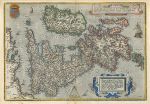
British Isles, Ortelius, 1584 or later

British Isles, Ortelius, 1584 or later.
"Angliae, Scotiae, et Hiberniae, sive Britannicae Insularum Descriptio." (map of the British Isles) by A. Ortelius, published about 1584 or later. Copper engraved map with old hand colouring, the verso has one side blank, the other has Dutch text. Click here for detail showing part of the map (London area). FAULTS - old closed tear to the lower part of the centrefold extending a few cms into the map area, slight dampstaining to the upper portion, soft crease across the lower right corner. Further images can be sent on request. Size 49.5 x 34.5 cms plus wide margins, with good plate mark. Ref F5770

 
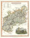
Gloucestershire, Fullarton, 1841

Gloucestershire, Fullarton, 1841.
"Gloucestershire" published by Fullarton & Co. in his Parliamentary Gazetteer, 1841. Steel engraved map with recent hand colour. Inset view of Gloucester Cathedral. Good condition with full plate mark, centrefold as published. Size 19 x 24.5 cms plus margins. Ref F5769

 
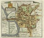
Gloucester plan, Van Der Aa, after John Speed, 1720

Gloucester plan, Van Der Aa, after John Speed, 1720.
"Glocester. Glovernia. Claudiocestria" town plan by Pierre Van Der Aa of about 1720, based on the original by John Speed of 1610. Copper engraved antique map, with recent hand colouring. Good condition. Size 13 x 12 cms plus good margins. Ref F5768

 
« Previous | ...1470 | 1471 | 1472 | 1473 | 1474 | 1475 | 1476 | 1477 | 1478 | 1479 | 1480... | Next »


© 2003 - 2020 Website copyright Steve Bartrick
Royalty free stock images of antique prints of interest to historians, students and family history researchers